


MapCircle
คำอธิบายของMapCircle
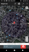
MapCircle is a simple app that allows you to visualize distances by displaying a map with an overlaid circle or donut of a specified radius.
The circle view is useful when you want to see everything that's less than some specified distance from some location.
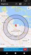
The donut view is useful when you know that something is "a mile away" (or some other distance), but aren't sure exactly WHERE it is & want to try and guess its likely location. The donut itself represents the region of uncertainty and margin of error.
Features:
* Distance in Miles and Kilometers
* Easily toggle between regular and hybrid map views (hybrid is aerial/satellite image with overlaid map)
* Two visualization types: circle and donut
MapCircle เป็น app ง่ายๆที่ช่วยให้คุณสามารถเห็นภาพในระยะทางโดยการแสดงแผนที่ที่มีวงกลมวางซ้อนหรือโดนัทของรัศมีที่กำหนด
มุมมองวงกลมจะเป็นประโยชน์เมื่อคุณต้องการที่จะเห็นทุกอย่างที่น้อยกว่าระยะทางที่กำหนดจากสถานที่ตั้งบางส่วน
มุมมองโดนัทจะเป็นประโยชน์เมื่อคุณรู้ว่าสิ่งที่เป็น "ห่าง" (หรือบางระยะอื่น ๆ ) แต่ไม่แน่ใจว่ามันอยู่ที่ไหนและต้องการที่จะลองและคาดเดาสถานที่ตั้งของแนวโน้ม โดนัทตัวเองเป็นตัวแทนของภูมิภาคของความไม่แน่นอนและขอบของข้อผิดพลาด
คุณสมบัติ:
* ระยะทางในไมล์และกิโลเมตร
* ได้อย่างง่ายดายสลับระหว่างมุมมองแผนที่ปกติและไฮบริด (ไฮบริดเป็นทางอากาศภาพ / ดาวเทียมแผนที่วางซ้อน)
* สองประเภทสร้างภาพ: วงกลมและโดนัท
MapCircle--เวอร์ชั่น1.05
(20-01-2020)MapCircle - ข้อมูล APK
เวอร์ชั่น APK: 1.05แพ็คเกจ: software.pantherkitty.mapcircleเวอร์ชั่นล่าสุดของMapCircle


แอปในประเภทเดียวกัน


